SUMMARY
This is AI generated summarization, which may have errors. For context, always refer to the full article.
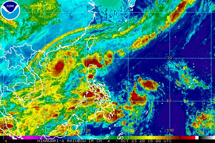
Tropical Depression Quinta maintained its strength while moving over the Philippine Sea on Friday evening, October 23, but it is expected to intensify over the weekend.
The Philippine Atmospheric, Geophysical, and Astronomical Services Administration (PAGASA) said in a bulletin released past 11 pm that Quinta is now 820 kilometers east northeast of Surigao City, Surigao del Norte, or 775 kilometers east of Guiuan, Eastern Samar.
After moving slowly on Friday afternoon, the tropical depression accelerated to 25 kilometers per hour (km/h), heading northwest.
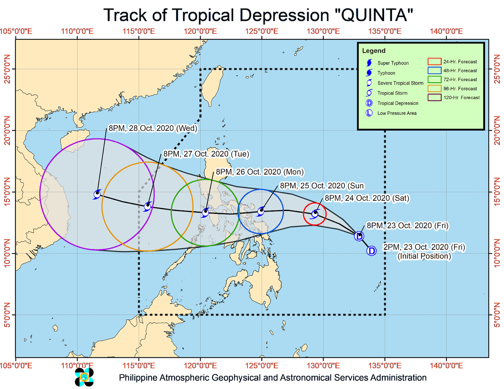
PAGASA said Quinta is now forecast to make landfall either in Bicol or Eastern Visayas between Sunday evening, October 25, and Monday morning, October 26, then cross Southern Luzon on Monday.
So far, Quinta still has maximum winds of 45 km/h and gustiness of up to 55 km/h. But PAGASA said it is seen to intensify into a tropical storm within 24 hours, and then may strengthen further into a severe tropical storm before making landfall.
“After crossing the Philippine archipelago, this tropical cyclone may continue intensifying over the West Philippine Sea,” added PAGASA. (READ: FAST FACTS: Tropical cyclones, rainfall advisories)
While Quinta remains relatively far from land, its trough or extension will already bring rain on Saturday, October 24. In addition, the trough of Typhoon Saudel outside the Philippine Area of Responsibility (PAR) – formerly Pepito when it was inside – will also cause rain.
Light to moderate rain, with at times heavy rain
- Mimaropa
- Bicol
- Visayas
- Mindanao
Saudel or the former Pepito is located 680 kilometers west of Sinait, Ilocos Sur, slowly moving west toward the central part of Vietnam. It left PAR on Thursday, October 22.
PAGASA added that “a stationary front currently extending over extreme Northern Luzon associated with a northeasterly surge” will trigger rain as well.
Moderate to heavy rain
- Batanes
- northern part of Cagayan including Babuyan Islands
- northern part of Apayao
- northern part of Ilocos Norte
Meanwhile, tropical cyclone wind signals have not been raised yet. PAGASA said Signal No. 1 could first be raised in parts of Bicol and Eastern Visayas on Saturday, “in anticipation of high winds that may prevail over these areas during the passage of Quinta.”
High winds to gale-force winds due to a northeasterly surge will also be experienced in:
- Batanes
- Babuyan Islands
- northern coastal areas of Ilocos Norte and mainland Cagayan
As for sea travel, a gale warning is in effect for these seaboards due to rough to very rough seas, with waves 2.8 to 6 meters high:
- seaboards of Northern Luzon
- western seaboards of Central Luzon, Batangas, Occidental Mindoro, and northern part of Palawan including Calamian and Kalayaan Islands
Moderate to rough seas, with waves 1.5 to 2.5 meters high, will also be experienced in these seaboards:
- western seaboard of southern part of Palawan
- eastern seaboards of Central Luzon and Southern Luzon
“Inexperienced mariners should avoid navigating in these conditions,” PAGASA said.
Based on its latest forecast track, Quinta might leave PAR on Tuesday, October 27.
Quinta is the Philippines’ 17th tropical cyclone for 2020, and the 4th for October, exceeding PAGASA’s previous projection of up to 3 for the month.
An average of 20 tropical cyclones form within or enter PAR each year. (READ: LIST: PAGASA’s names for tropical cyclones in 2020)
These are PAGASA’s latest estimates for the number of tropical cyclones inside PAR in the next 6 months:
- November 2020 – 1 to 3
- December 2020 – 2 or 3
- January 2021 – 0 or 1
- February 2021 – 0 or 1
- March 2021 – 0 or 1
- April 2021 – 0 or 1
Last October 2, the state weather bureau warned Filipinos to expect more rain in the coming months due to the onset of La Niña. – Rappler.com
Add a comment
How does this make you feel?


There are no comments yet. Add your comment to start the conversation.