SUMMARY
This is AI generated summarization, which may have errors. For context, always refer to the full article.
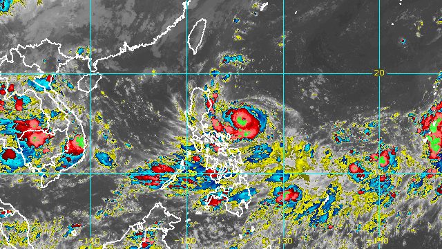
MANILA, Philippines – Karding (Noru) swiftly strengthened from a severe tropical storm into a typhoon at 5 pm on Saturday, September 24, the weather bureau announced in a bulletin released past 8 pm.
The Philippine Atmospheric, Geophysical, and Astronomical Services Administration (PAGASA) said Karding now has maximum sustained winds of 120 kilometers per hour from the previous 110 km/h. Its gustiness increased to 150 km/h from 135 km/h.
PAGASA warned that Karding may intensify further before it hits land.
As of early Saturday evening, the typhoon was located 490 kilometers east of Baler, Aurora. It slightly slowed down, moving southwest at 20 km/h from the previous 25 km/h.
Karding could make landfall in the southern part of Aurora or the northern part of Quezon on Sunday afternoon or early evening, September 25.
Then it is expected to cross Central Luzon – still as a typhoon – before emerging over the West Philippine Sea late Sunday evening or early Monday morning, September 26.
PAGASA raised Signal No. 3 for the first time at 8 pm on Saturday. These are the areas under tropical cyclone wind signals:
Signal No. 3
Storm-force winds (89 to 117 km/h), moderate to significant threat to life and property
- northern part of Camarines Norte (Vinzons)
- eastern part of Polillo Islands (Kalongkooan Island, Kalotkot Island, Patnanungan Island, Jomalig Island)
Signal No. 2
Gale-force winds (62 to 88 km/h), minor to moderate threat to life and property
- southern part of Isabela (Dinapigue, San Guillermo, Jones, San Agustin, Echague, San Mariano)
- Quirino
- central and southeastern parts of Nueva Vizcaya (Alfonso Castañeda, Dupax del Sur, Aritao, Santa Fe, Bambang, Dupax del Norte, Kasibu, Quezon, Bayombong, Diadi)
- Aurora
- Nueva Ecija
- eastern part of Tarlac (Concepcion, La Paz, Victoria, Pura, Ramos, Anao, San Manuel, Moncada, Paniqui, Gerona, Tarlac City)
- Bulacan
- eastern part of Pampanga (Apalit, San Simon, San Luis, Candaba, Santa Ana, Arayat, Magalang)
- Metro Manila
- northern and central parts of Quezon (General Nakar, Infanta, Real, Mauban, Calauag, Perez, Alabat, Quezon, Tagkawayan, Guinayangan, Sampaloc, Lucban, Tayabas City, Lucena City, Pagbilao, Padre Burgos, Atimonan, Agdangan, Unisan, Plaridel, Gumaca, Lopez, Pitogo) including the rest of Polillo Islands
- northern and central parts of Laguna (Santa Maria, Siniloan, Famy, Mabitac, Pakil, Pangil, Paete, Kalayaan, Lumban, Cavinti, Santa Cruz, Pagsanjan, Magdalena, Luisiana, Majayjay, Liliw, Pila, Victoria, Nagcarlan, Bay, Los Baños, Calamba City, Santa Rosa City, Biñan City, San Pedro City, Cabuyao City, Rizal, Calauan)
- northeastern part of Cavite (Bacoor City, Kawit, Imus City, Dasmariñas City, Carmona, General Mariano Alvarez, Cavite City)
- Rizal
- eastern part of Pangasinan (Umingan, Bautista, Alcala, Rosales, Balungao, Santa Maria, San Quintin, Natividad, Tayug, Asingan, San Nicolas, San Manuel, Santo Tomas, Bayambang, Malasiqui, Villasis, Urdaneta City, Binalonan, Laoac, Sison, Pozorrubio)
- northern part of Camarines Sur (Del Gallego, Ragay, Lupi, Sipocot, Siruma, Lagonoy, Garchitorena, Caramoan, Tinambac, Presentacion, San Jose, Goa, Cabusao, Libmanan, Calabanga, Bombon, Magarao)
- northern and central parts of Catanduanes (Caramoran, Pandan, Bagamanoc, Panganiban, Viga, San Miguel, Baras, Gigmoto, San Andres)
- rest of Camarines Norte
Signal No. 1
Strong winds (39 to 61 km/h), minimal to minor threat to life and property
- southern part of Cagayan (Peñablanca, Iguig, Tuguegarao City, Enrile, Solana, Tuao, Piat, Amulung, Rizal)
- rest of Isabela
- rest of Nueva Vizcaya
- southern part of Apayao (Conner)
- Abra
- Kalinga
- Mountain Province
- Ifugao
- Benguet
- southern part of Ilocos Norte (Nueva Era, Badoc, Pinili, Banna, Batac City, Currimao, Paoay, Marcos)
- Ilocos Sur
- La Union
- rest of Pangasinan
- rest of Tarlac
- rest of Pampanga
- Zambales
- Bataan
- rest of Laguna
- rest of Quezon
- rest of Cavite
- Batangas
- rest of Camarines Sur
- Albay
- rest of Catanduanes
- Marinduque
- northwestern part of Occidental Mindoro (Lubang Islands, Paluan, Abra de Ilog)
- northwestern part of Oriental Mindoro (San Teodoro, Puerto Galera, Calapan City, Baco)
The highest possible wind signal due to Karding is Signal No. 4.
Aside from strong winds, the typhoon will also dump rain, especially on Sunday. Here is PAGASA’s latest rainfall forecast:
Saturday evening, September 24, until early Sunday morning, September 25
Light to moderate rain, with at times heavy rain
- Batanes
- Cagayan
- Isabela
- northern part of Aurora
- Catanduanes
- Camarines Norte
- Camarines Sur
Rest of Sunday, September 25, until early Monday morning, September 26
Heavy to intense rain, with at times torrential rain
- northern part of Quezon including Polillo Islands
- Aurora
- Nueva Ecija
- Tarlac
- Pangasinan
- northern part of Zambales
Heavy to intense rain
- rest of Central Luzon
Moderate to heavy rain
- Cagayan
- Isabela
- Quirino
- Nueva Vizcaya
- Ilocos Norte
- Ilocos Sur
- La Union
- Cordillera Administrative Region
- Metro Manila
- rest of Calabarzon
Affected areas must watch out for floods and landslides.
Karding will also enhance the southwest monsoon or hanging habagat, which may bring occasional rain to most of Southern Luzon and the Visayas, especially their western sections, beginning Saturday or Sunday.
Meanwhile, a gale warning remains in effect for the eastern seaboards of Luzon, particularly Cagayan, Isabela, Aurora, and Polillo Islands. Seas are rough to very rough, with waves 2.8 to 4.5 meters high. Fishing boats should not sail while larger vessels must be on alert.
In the northern and western seaboards of Northern Luzon, seas are moderate to rough, with waves 1.5 to 3.5 meters high. Conditions may be risky for small vessels.
Karding could exit the Philippine Area of Responsibility (PAR) on Monday.

Karding is the Philippines’ 11th tropical cyclone for 2022.
It is also the third tropical cyclone for September, after Typhoon Inday (Muifa) and Super Typhoon Josie (Nanmadol). Inday and Josie did not make landfall in the country.
PAGASA expects 7 to 11 tropical cyclones to enter or develop inside PAR from September 2022 to February 2023. Per month, these are the weather bureau’s estimates:
- September 2022 – 2 or 3
- October 2022 – 2 to 4
- November 2022 – 2 or 3
- December 2022 – 1 or 2
- January 2023 – 0 or 1
- February 2023 – 0 or 1
– Rappler.com
Add a comment
How does this make you feel?


There are no comments yet. Add your comment to start the conversation.