SUMMARY
This is AI generated summarization, which may have errors. For context, always refer to the full article.
Claim:
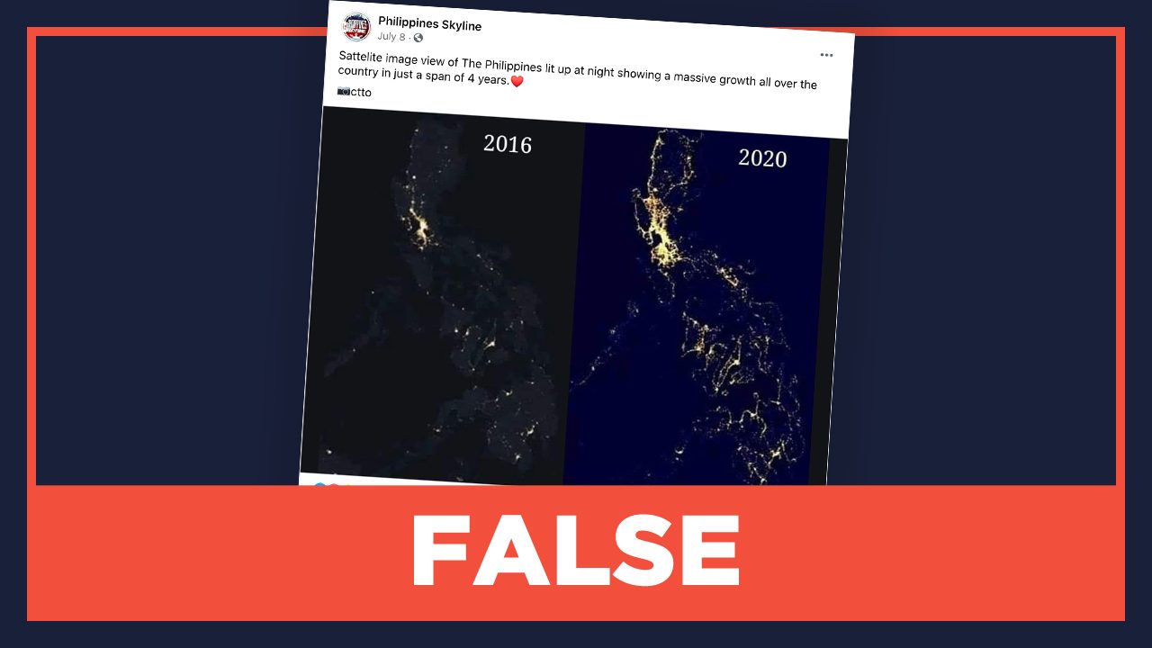
Satellite imagery of night lights in the Philippines in 2020 shows “massive” development compared to 4 years ago.
Facebook page Philippines Skyline posted a graphic on July 8 comparing night lights satellite images of the Philippines in 2016 and 2020. Its caption said, “Sattelite image view of The Philippines lit up at night showing a massive growth all over the country in just a span of 4 years.”

The post was spotted by a member of the Rappler team. Many of the comments in the post credited President Rodrigo Duterte for the supposed development. As of writing, it had 372 shares, 301 reactions, and 46 comments.
Rating: FALSE
The facts:
The National Aeronautics and Space Administration’s (NASA) Black Marble project, where the 2016 image in Philippine Skyline’s post was taken from, has not yet produced composite satellite images for the year 2020.
In a response to Rappler’s email about the authenticity of the 2020 satellite imagery, NASA scientific programmer and analyst Ranjay Shrestha said, “The attached image appears to be post-processed using some image enhancing techniques (including image scaling) so we can’t vouch for the validity and accuracy of the image.”
Shrestha explained that the composite Black Marble data was produced for 2012 and 2016 only. The Black Marble team also recently released adjusted nighttime lights on August 26, but these were only until 2015. Shrestha said they will continue processing data until it reaches the year 2020.
He also said that there is a way to view real-time visualization of night lights, but that the output is unlike the one released by Black Marble.
“NASA worldview archives Visible Infrared Imaging Radiometer Suite (VIIRS) global nighttime light images that could be potentially used for real-time nightlight visualization. Please note that these are raw top of atmosphere images with various contaminations (cloud, aerosols, moonlight, etc) and not ideal for quantitative analysis,” Shrestha said. This can be viewed in NASA’s interactive interface.
Both the National Oceanic and Atmospheric Administration and Google Earth cite NASA’s Black Marble and VIIRS tools in their night lights imageries.
Rappler also reached out to Philippines Skyline to ask for the source or the tool used in creating the satellite image but we received no response. – Pauline Macaraeg/Rappler.com
Keep us aware of suspicious Facebook pages, groups, accounts, websites, articles, or photos in your network by contacting us at factcheck@rappler.com. Let us battle disinformation one Fact Check at a time.
Add a comment
How does this make you feel?


There are no comments yet. Add your comment to start the conversation.