SUMMARY
This is AI generated summarization, which may have errors. For context, always refer to the full article.
MANILA, PHILIPPINES — With the increasing calls for global climate action, a newly developed method by Singaporean researchers for accurately measuring stored carbon in raised peatlands can aid in achieving climate targets.
Researchers at Singapore-MIT Alliance for Research and Technology (SMART) – the Massachusetts Institute of Technology’s research enterprise in Singapore – and Nanyang Technological University, Singapore (NTU Singapore) advanced carbon measurement of bogs or raised peatlands using satellite data, reducing the need for on-site sampling to get its three-dimensional shapes.
“Our approach enables planning of restoration and protection measures to do just this [slowing down or stopping emissions]. Thus, our method is a step toward reaching global climate goals while preserving biodiversity and preventing wildfires,” said Alex Cobb, the first author and senior principal research scientist at SMART, in an interview with Rappler.
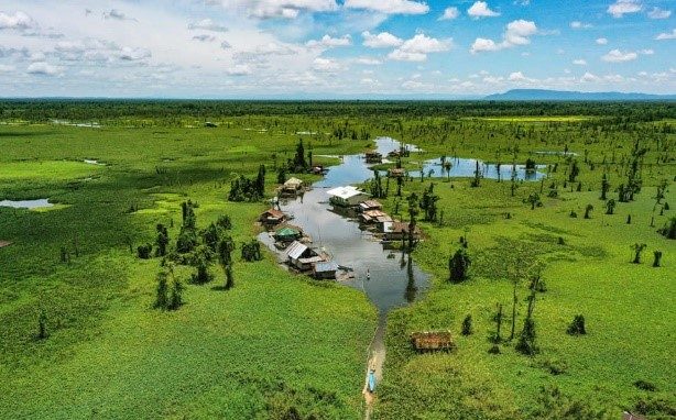
Peatlands are a type of terrestrial wetland ecosystem covered by soggy mounds of peat, or the accumulated partially decomposed organic matter often from plant materials, wherein its waterlogged conditions prevent organic matter from fully decomposing.
Carbon sinks like peatlands absorb more carbon dioxide from the atmosphere than it releases. The continuous increase of carbon dioxide released into the atmosphere causes global warming and climate change, with a scientific consensus that these are primarily due to human activities.
“Peatlands cover just 3% of the Earth’s land surface but store twice as much carbon as all the world’s forests. However, in the last few decades, peatlands have released an enormous amount of carbon dioxide because of drainage by humans,” Cobb explained.
Humans worldwide have drained peatlands for centuries to accommodate agricultural demand, extract peat, produce forestry land, and many others, leading to 2 billion tons of carbon dioxide released into the atmosphere yearly.
“Peatland drainage has left them vulnerable to catastrophic fires, with the resulting haze or smog causing widespread harm to human health,” Cobb added.
With Southeast Asia being home to almost 23 million hectares of peatlands, having dried and flammable peat in tropical regions increases the threat of catastrophic fires.
Measuring stored carbon and nature-based solutions
The SMART-NTU researchers’ method cuts down not only time and effort from a manual or aircraft-assisted measurement of peatlands and peat volume for carbon stock but also millions of dollars often put into these kinds of survey projects.
“The new mathematical model can be applied to any bog worldwide, overcoming the limitations of existing methods whose accuracy is limited to specific conditions,” Cobb explained.
The researchers used Light Detection and Ranging or LIDAR technology to check the validity of deriving the shape of bogs from their model.

Rewetting peatlands, a nature-based climate solution, is part of global peatland restoration projects that target 50% of all lost peatlands by 2030. Not only will it support carbon sequestration but also long-term biodiversity restoration.
“By estimating the shape of raised peatlands from limited data, the new method by the SMART-NTU team makes it possible to plan peatland rewetting [and restoration] more easily than has ever been possible before,” Cobb shared, as they could determine which parts are wet, intact, dry, or damaged.
Philippine peatlands and Southeast Asia efforts
In the Philippines, peatland awareness is fairly low, with most people familiar with peat as a gardening material (e.g. peat moss, coco peat). As these are extracted from peatlands, the continuous selling of these materials can be counterproductive to restoration efforts.
The country has two major peatlands: the Leyte Sab-a Basin in Leyte and the Agusan Marsh in Agusan del Sur. Only nine peatlands have been identified in the country, and they continue to be threatened by massive land conversion and fires.
In 2019, major peatland fires occurred in dry areas of the Leyte Sab-a Basin and Agusan Marsh, with the locals left without early warning signs or the capacity to fight against the fires.
In May 2023, lawmakers in the House of Representatives approved on final reading House Bill 8204, which seeks to prohibit drainage, clearing, deforestation, introduction of invasive species, and dumping of waste in peatlands.
Under this proposed law, peatlands tagged as agricultural lands would also be reclassified as national parks or forest lands. The Department of Environment and Natural Resources (DENR) had already announced its ongoing nationwide peatland inventory in 2020, which they recently confirmed to Rappler that it is still ongoing.
A mangrove ecologist from the University of the Philippines, Dr. Severino G. Salmo III, mentioned to Rappler that while the technology is not “entirely” new, he highlighted that it is good to use mapping/machine learning technologies, like Lidar, in measuring carbon, yet it is not entirely perfect. ‘The paper said it perfectly, It is a “model”. And, the “model output” is of course not absolute. You need ground validation and empirical measurements to calibrate the model,’ Salmo added. Since there are also several Filipino scientists working on carbon measurement, especially for wetlands, partnerships are highly viable to improve solutions further.
With the size of peatland coverage in Southeast Asia, some countries have claimed progress in their conservation efforts. Indonesia, for example, has allegedly restored almost 3.7 million hectares of peatland as announced by its government. However, The Gecko Project’s investigation found that the claims were exaggerated from an actual number of 2.7 million hectares (based on the required 40 cm water level).
Partnership and future studies
This new method of carbon measurement of raised peatlands shines a light on global efforts toward peatland ecosystem awareness and restoration.
“The global team of researchers will expand their analyses to remote peatland regions for which few data are available. They will develop tools to estimate carbon stocks with this new method to support governmental agencies and the private sector in reducing greenhouse gas emissions from degraded peatlands,” Cobb said.
While the researchers currently do not have engagements in the Philippines, Cobb said they are interested in the applications of their method in the country’s peatland restoration efforts. – Rappler.com
Add a comment
How does this make you feel?


![[EDITORIAL] Kamaynilaan para sa tao, hindi para sa mga sasakyan](https://www.rappler.com/tachyon/2024/04/animated-traffic-april-2024-carousel.jpg?resize=257%2C257&crop=410px%2C0px%2C720px%2C720px)
There are no comments yet. Add your comment to start the conversation.