SUMMARY
This is AI generated summarization, which may have errors. For context, always refer to the full article.

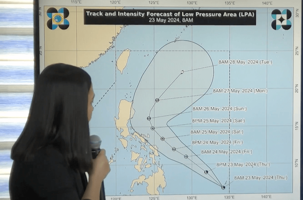
MANILA, Philippines – The weather bureau warned of potentially heavy rain in the coming days as the low pressure area (LPA) that it has been monitoring entered the Philippine Area of Responsibility (PAR) at around 5 am on Thursday, May 23.
As of 10 am, the LPA was located 870 kilometers east of southeastern Mindanao, according to the Philippine Atmospheric, Geophysical, and Astronomical Services Administration (PAGASA).
The LPA is seen to develop into a tropical depression within 24 hours, or by Friday morning, May 24.
It will be given the local name Aghon as the Philippines’ first tropical cyclone for 2024.
PAGASA said in a briefing on Thursday that the LPA or potential Aghon could move generally northwest until Saturday, May 25, then recurve northeast by Sunday, May 26.
That means the weather disturbance might remain offshore or over the Philippine Sea, but PAGASA also warned that it could still be near landmass. In particular, it may be nearest the Bicol-Eastern Visayas area on Saturday.
PAGASA Weather Specialist Ana Clauren-Jorda added that landfall is not being ruled out, given what the weather bureau describes as the “high” uncertainty in the LPA’s track for the first 48 hours.
The track can still change due to the “broad circulation of the disturbance right now,” PAGASA said.
On Thursday, the trough or extension of the LPA may already trigger light to heavy rain in Surigao del Norte, Surigao del Sur, and Dinagat Islands.
On Friday, Eastern Samar and Northern Samar could have moderate to heavy rain, while Bicol, Caraga, and the rest of Eastern Visayas may see light to moderate rain.
By Saturday, or when the potential Aghon would be nearest the Bicol-Eastern Visayas area, moderate to intense rain is possible in Catanduanes, Camarines Sur, and Northern Samar. Light to moderate rain is also expected in Quezon including Polillo Islands, the rest of Bicol, and the rest of Eastern Visayas.
Science and Technology Secretary Renato Solidum Jr. called on local government units and the public to prepare for the effects of rainfall.
“Kailangan nating pag-ingatan ang posibleng pagkakaroon ng pagbaha at landslide sa mga lugar…na posibleng makaranas ng malalakas na pag-ulan,” Solidum said during Thursday’s briefing.
(We need to take precautions for possible floods and landslides in areas that may experience heavy rain.)
For strong winds, tropical cyclone wind signals could be raised as early as Friday for parts of Bicol and Eastern Visayas.
In terms of intensity, the weather disturbance may strengthen into a tropical storm by Sunday morning, and then as it recurves, into a severe tropical storm by Tuesday, May 28.
ALSO ON RAPPLER
- DFA chief: Where’s China’s proof of West Philippine Sea agreements?
- Who is Chelsea Manalo, Miss Universe Philippines 2024?
- AVC Challenge Cup 2024: Where to watch, buy tickets, get to venue
- IN PHOTOS: Dutch Queen Máxima visits Philippine fisherfolk in push for financial inclusion
Not rainy season yet
The arrival of the LPA or Aghon does not automatically mean the start of the Philippines’ rainy season, which is usually declared in the second half of May or first half of June.
PAGASA Deputy Administrator for Research and Development Marcelino Villafuerte II explained that none of the 13 stations being monitored for amount of rainfall have met the criteria yet.
These stations are also in the western part of the country, while the LPA or Aghon will mostly affect the eastern portion, based on the initial forecast.
Aghon may pull the southwesterly windflow, which would affect the western part of the country, but it remains to be seen if the stations would meet the rainfall criteria. For now, the warm and dry season is still winding down.
El Niño also continues to weaken and a transition to neutral conditions is expected. But there is a 60% chance of La Niña developing in the June-August period.
According to Villafuerte, 13 to 16 tropical cyclones may form within or enter PAR in 2024. There were 11 tropical cyclones in 2023. – Rappler.com
Add a comment
How does this make you feel?


There are no comments yet. Add your comment to start the conversation.