SUMMARY
This is AI generated summarization, which may have errors. For context, always refer to the full article.

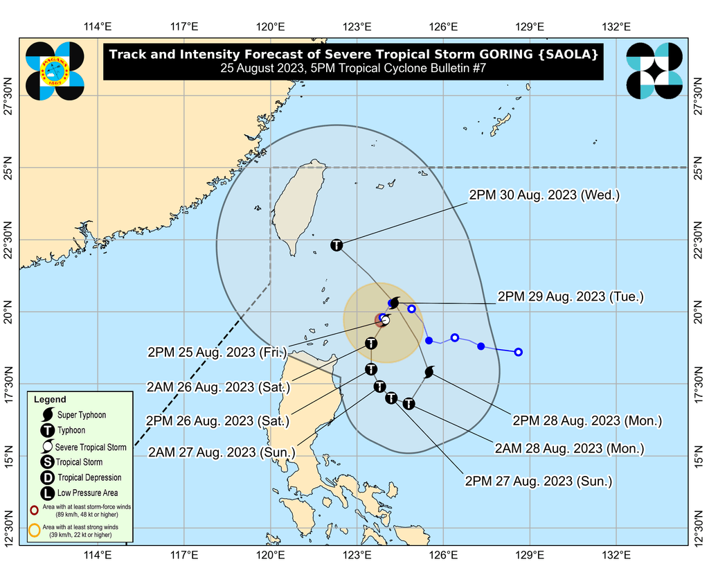
MANILA, Philippines – Goring (Saola) intensified from a tropical storm into a severe tropical storm on Friday afternoon, August 25, with its maximum sustained winds increasing from 85 kilometers per hour to 110 km/h.
The Philippine Atmospheric, Geophysical, and Astronomical Services Administration (PAGASA) also said in its 5 pm bulletin on Friday that Goring’s gustiness is now up to 135 km/h from the previous 105 km/h.
The severe tropical storm will rapidly intensify further, added PAGASA, and possibly strengthen into a typhoon by Saturday, August 26.
Goring may then reach its maximum strength by Monday, August 28, when it could become a super typhoon. Monday is a regular holiday in the country for National Heroes Day.
As of Friday afternoon, Goring was located 260 kilometers east of Calayan, Cagayan, slowly moving southeast. It is generally a slow-moving tropical cyclone.
ALSO ON RAPPLER
- LIVE UPDATES: Philippines vs Dominican Republic – FIBA World Cup 2023
- Strength of the pack: Chot Reyes expects entire Gilas frontline to collectively control Towns
- [ANALYSIS] Brace yourselves for higher rice prices under Marcos
- Kathryn Bernardo speaks up on need for privacy, personal space after ‘vaping’ video
While Goring remains over the Philippine Sea, its outer rainbands already started bringing rain to parts of Northern Luzon on Friday.
Rain will persist in the coming days, with floods and landslides possible.
Friday afternoon, August 25, to Saturday afternoon, August 26
- 50-100 millimeters (mm): Batanes, Babuyan Islands, northeastern part of mainland Cagayan
Saturday afternoon, August 26, to Sunday afternoon, August 27
- 100-200 mm: eastern part of mainland Cagayan, eastern part of Isabela, northern part of Aurora
- 50-100 mm: Babuyan Islands, Ilocos Norte, Ilocos Sur, rest of mainland Cagayan, rest of Isabela
Sunday afternoon, August 27, to Monday afternoon, August 28
- 50-100 mm: Ilocos Norte, Ilocos Sur, northern part of Aurora, eastern part of Cagayan, eastern part of Isabela
Signal No. 1 remains raised in the same areas as of 5 pm on Friday. The following will have strong winds from Goring:
- Batanes
- eastern part of Babuyan Islands (Babuyan Island, Camiguin Island)
- eastern part of mainland Cagayan (Santa Ana, Gonzaga, Lal-lo, Gattaran, Baggao, Peñablanca, Santa Teresita, Buguey, Camalaniugan, Aparri)
- eastern part of Isabela (Maconacon, Divilacan, Palanan, Dinapigue, San Mariano, San Pablo, Cabagan, Tumauini, Ilagan City)
PAGASA noted that if Goring’s track shifts westward, it may raise higher tropical cyclone wind signals.
The weather bureau also issued a new gale warning due to the severe tropical storm at 5 pm. Rough to very rough seas, with waves 2.8 to 4.5 meters high, are expected in these seaboards:
- northern and eastern seaboards of Northern Luzon (Batanes, Cagayan including Babuyan Islands, Isabela)
- eastern seaboard of Central Luzon (Aurora)
PAGASA advised fishing boats and other small vessels not to sail, and larger vessels to watch out for big waves.
The weather bureau expects Goring to head south southwest or south off Northern Luzon until Saturday evening, then south or south southeast until Sunday afternoon.
Then it could “loop northward before turning to the northwest” on Tuesday, August 29, toward the Luzon Strait. A high pressure area has been influencing Goring’s movement.
Goring will also enhance the southwest monsoon or habagat, which may bring “significant” rain during the weekend, particularly in these provinces:
Saturday, August 26
- 50-100 mm: Zambales, Bataan, Occidental Mindoro
Sunday, August 27
- 50-100 mm: Zambales, Bataan, Cavite, Batangas, Occidental Mindoro, northern part of Palawan including Calamian and Cuyo islands, Antique
But the southwest monsoon – not yet enhanced by Goring – has been bringing scattered rain showers and thunderstorms to Palawan, Occidental Mindoro, Zambales, and Bataan on Friday. Other areas in Central Luzon, Southern Luzon, the Visayas, and Mindanao have isolated rain showers or thunderstorms.
The enhanced southwest monsoon will also trigger gusty conditions in these areas during the weekend:
Saturday, August 26
- Aurora, Bataan, Metro Manila, Calabarzon, most of Mimaropa, Bicol, most of Visayas, Dinagat Islands
Sunday, August 27
- Aurora, Bataan, Metro Manila, Calabarzon, Mimaropa, Bicol, Visayas, Dinagat Islands, Surigao del Norte
Goring is the Philippines’ seventh tropical cyclone for 2023 and the first for August.
PAGASA previously said it expects two or three tropical cyclones to develop within or enter the Philippine Area of Responsibility (PAR) in August.
The weather bureau also continues to monitor a low pressure area that formed outside PAR on Friday. – Rappler.com
Add a comment
How does this make you feel?


There are no comments yet. Add your comment to start the conversation.