SUMMARY
This is AI generated summarization, which may have errors. For context, always refer to the full article.

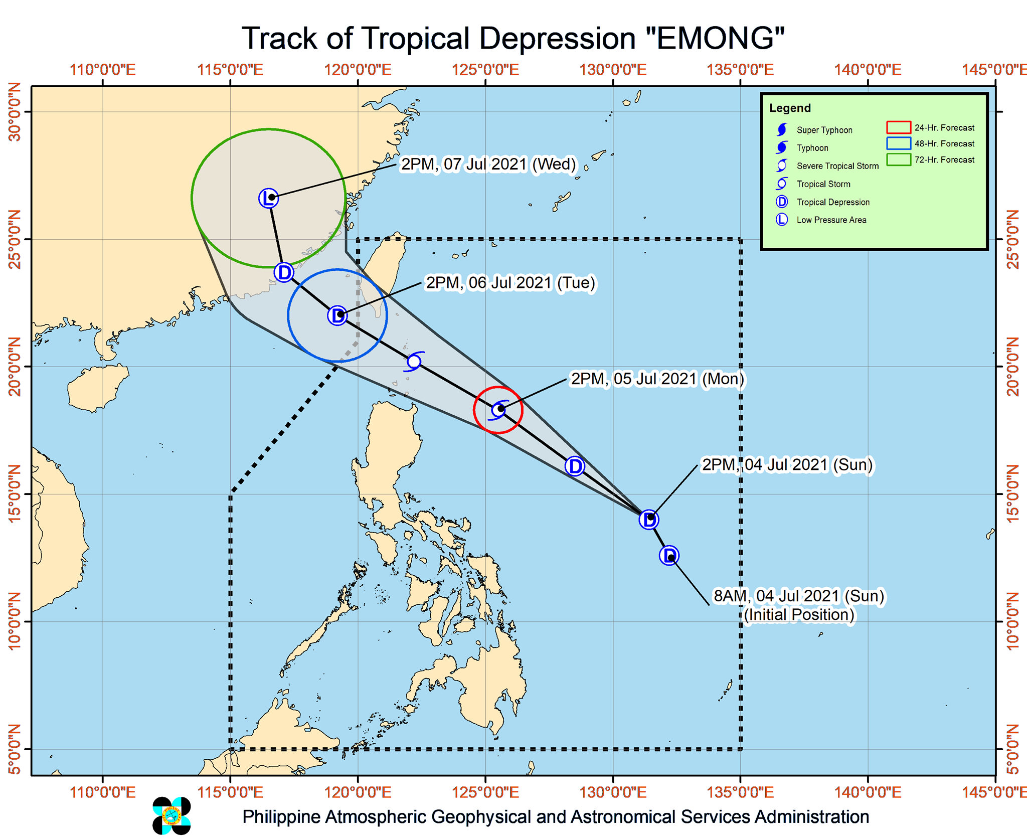
Tropical Depression Emong slightly strengthened as it moved over the Philippine Sea on Sunday afternoon, July 4.
In its 5 pm bulletin on Sunday, the Philippine Atmospheric, Geophysical, and Astronomical Services Administration (PAGASA) said Emong now has maximum sustained winds of 55 kilometers per hour and gustiness of up to 70 km/h.
It previously had maximum sustained winds of 45 km/h and gustiness of up to 55 km/h.
PAGASA now expects Emong to intensify into a tropical storm in the next 24 hours. (READ: FAST FACTS: Tropical cyclones, rainfall advisories)
As of Sunday afternoon, Emong was located 780 kilometers east of Virac, Catanduanes, moving north northwest at the same speed of 25 km/h.
It is heading for the Batanes-Babuyan Islands area, where it is expected to bring moderate to heavy rain from Monday evening, July 5, to Tuesday afternoon, July 6. The rain may also be intense at times.
PAGASA warned that scattered floods and landslides are highly likely.
Signal No. 1 remains raised in the following areas as of 5 pm on Sunday:
- Batanes
- northeastern part of Cagayan (Santa Ana, Gonzaga) including Babuyan Islands
Areas under Signal No. 1 should expect strong winds.
If Emong does intensify into a tropical storm as projected, the tropical cyclone wind signal in Batanes and the Babuyan Islands could be raised to Signal No. 2. (READ: Why is it now called tropical cyclone ‘wind’ – and not ‘warning’ – signals?)
After crossing the Batanes-Babuyan Islands area, Emong could weaken back into a tropical depression by Tuesday afternoon and then into a remnant low by Wednesday, July 7.
Emong is the Philippines’ fifth tropical cyclone for 2021 and the first for July. (READ: LIST: PAGASA’s names for tropical cyclones in 2021)
An average of 20 tropical cyclones form within or enter the Philippine Area of Responsibility (PAR) each year. For the rest of 2021, these are PAGASA’s estimates per month:
- July – 1 to 3
- August – 2 or 3
- September – 2 or 3
- October – 2 or 3
- November – 2 or 3
- December – 1 or 2
There is also a low pressure area (LPA) inside PAR, last spotted 225 kilometers west of Calapan City, Oriental Mindoro, on Sunday afternoon.
PAGASA earlier said the LPA remains “less likely” to become a tropical depression.
But the LPA and the southwest monsoon or hanging habagat are bringing scattered rain and thunderstorms to these areas:
- Metro Manila
- Central Luzon
- Calabarzon
- Mimaropa
- Bicol
- Visayas
- Mindanao
Affected areas must stay on alert for possible floods and landslides.
The state weather bureau declared the start of the rainy season last June 4. (READ: PAGASA joins TikTok to reach young Filipinos) – Rappler.com
Add a comment
How does this make you feel?


There are no comments yet. Add your comment to start the conversation.