SUMMARY
This is AI generated summarization, which may have errors. For context, always refer to the full article.

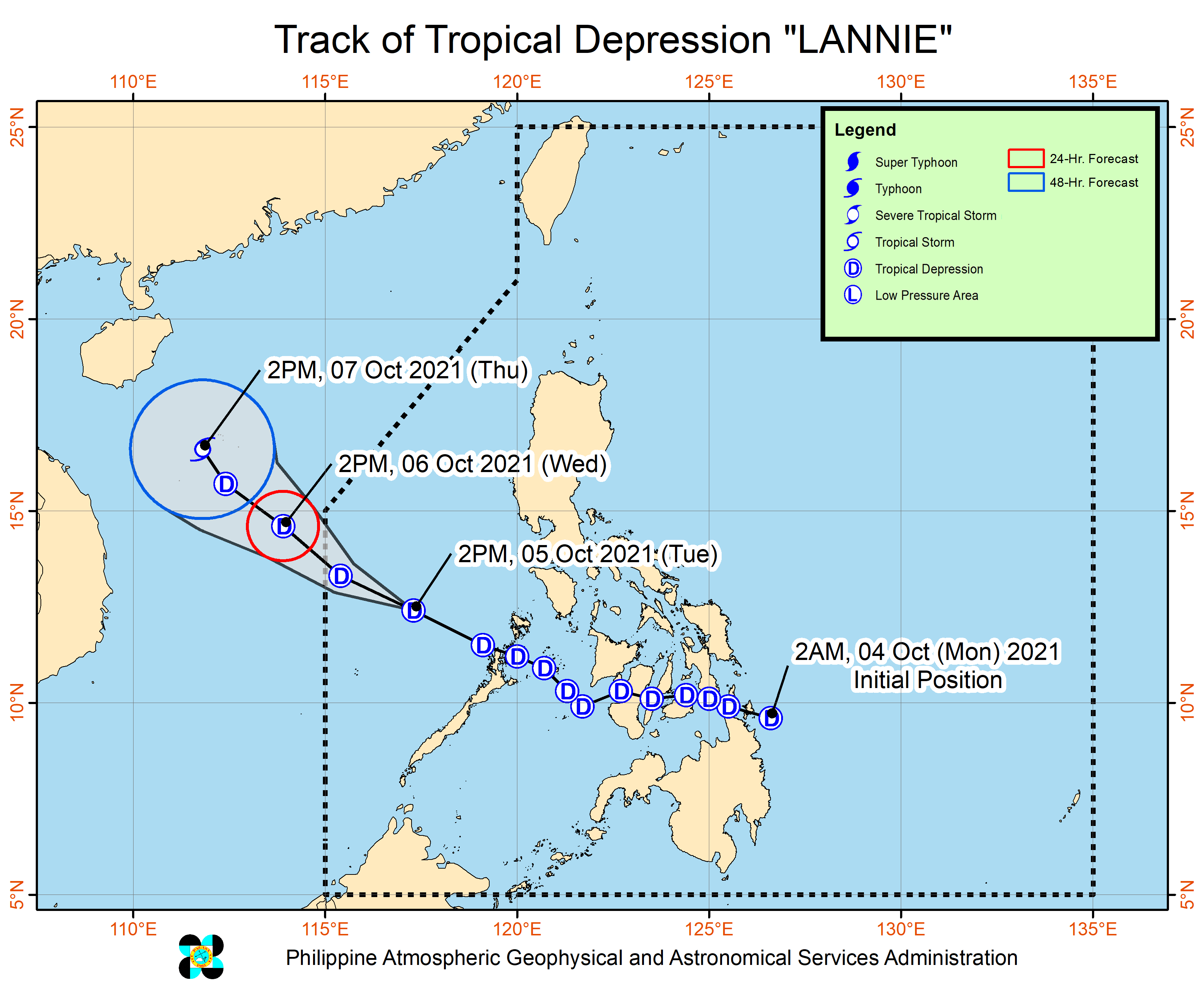
Tropical Depression Lannie accelerated over the West Philippine Sea on Tuesday afternoon, October 5, continuing to move away from land, though rain was still being experienced in parts of the country.
A new low pressure area (LPA) is also being monitored outside the Philippine Area of Responsibility (PAR).
Tropical Depression Lannie
Lannie was last spotted 380 kilometers west of Coron, Palawan, or 465 kilometers west of San Jose, Occidental Mindoro, said the Philippine Atmospheric, Geophysical, and Astronomical Services Administration (PAGASA) in its 5 pm bulletin on Tuesday.
The tropical depression is now moving west northwest at 30 kilometers per hour (km/h). At that pace, it could leave PAR on Wednesday morning, October 6.
Lannie’s intensity has stayed unchanged, with maximum sustained winds of 45 km/h and gustiness of up to 55 km/h. (READ: FAST FACTS: Tropical cyclones, rainfall advisories)
Signal No. 1, the only tropical cyclone wind signal raised due to Lannie, was already lifted as of 11 am on Tuesday. This means strong winds from the tropical depression are no longer a threat.
Isolated to scattered floods and landslides remain likely, however, as rain persists in several regions and provinces.
Moderate to heavy rain
- Palawan including Calamian, Kalayaan, and Cuyo Islands
Light to moderate rain, with at times heavy rain
- rest of Mimaropa
- Cagayan Valley
- Cordillera Administrative Region
- Calabarzon
- Bicol
- Aurora
- Ilocos Norte
- Western Visayas
- Zamboanga Peninsula
- Bangsamoro Autonomous Region in Muslim Mindanao
PAGASA also said Lannie is enhancing the easterly flow, prompting a gale warning for the seaboards of Northern Luzon and the western seaboard of Palawan. Waters are rough to very rough, with waves 2.8 to 4.5 meters high.
Fishing boats and other small vessels are advised not to sail, while larger vessels should watch out for big waves, said the weather bureau.
In the rest of the Philippines’ coastal waters, moderate to rough seas are expected. Travel is risky for small vessels.
After Lannie leaves PAR on Wednesday morning, it is expected to move toward the Chinese island province of Hainan. It could also intensify into a tropical storm by Thursday, October 7.
Lannie hit land in the Philippines a total of 10 times:
Monday, October 4
- Bucas Grande Island, Socorro, Surigao del Norte – 4:30 am
- Cagdianao, Dinagat Islands – 5 am
- Liloan, Southern Leyte – 7:30 am
- Padre Burgos, Southern Leyte – 8 am
- Mahanay Island, Talibon, Bohol – 12:30 pm
- Banacon Island, Jetafe, Bohol – 12:45 pm
- San Fernando, Cebu – 1:45 pm
- Guihulngan City, Negros Oriental – 3:30 pm
Tuesday, October 5
- Iloc Island, Linapacan, Palawan – 6:15 am
- El Nido, Palawan – 6:45 am
Low pressure area
Meanwhile, the new LPA was located 1,645 kilometers east of Mindanao as of Tuesday afternoon.
PAGASA Weather Specialist Ariel Rojas said the LPA may enter PAR on Wednesday evening or Thursday morning.
It could develop into a tropical depression on Friday, October 7, or Saturday, October 8, and would be given the local name Maring.
At the moment, it is seen to move northwest, with landfall “less likely.”
But Rojas advised the public to regularly monitor updates since forecasts may still change.
Lannie is the Philippines’ 12th tropical cyclone for 2021. It is also the first tropical cyclone for the month of October, coming right in the middle of the filing of certificates of candidacy for the 2022 elections, which is taking place across the country. The filing of COCs is until Friday.
An average of 20 tropical cyclones form within or enter PAR each year. (READ: LIST: PAGASA’s names for tropical cyclones in 2021)
These are PAGASA’s latest estimates for the next six months:
2021
- October – 2 or 3
- November – 2 or 3
- December – 1 or 2
2022
- January – 0 or 1
- February – 0 or 1
- March – 0 or 1
The weather bureau is also monitoring the possible emergence of La Niña in the fourth quarter of 2021. – Rappler.com
Add a comment
How does this make you feel?


There are no comments yet. Add your comment to start the conversation.