SUMMARY
This is AI generated summarization, which may have errors. For context, always refer to the full article.
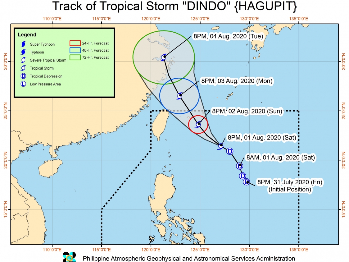
Dindo strengthened from a tropical depression into a tropical storm on Saturday evening, August 1.
It was given the international name Hagupit, a name contributed by the Philippines.
In a bulletin issued 11 pm on Saturday, the Philippine Atmospheric, Geophysical, and Astronomical Services Administration (PAGASA) said Dindo now has maximum winds of 65 kilometers per hour (km/h) from the previous 55 km/h and gustiness of up to 80 km/h from the previous 70 km/h.
PAGASA expects Dindo to intensify further in the next 2 to 3 days, possibly reaching severe tropical storm category by Monday morning, August 3.
There are no areas under tropical cyclone wind signals since Dindo will stay far from land and it has no direct impact on the country.
As of Saturday evening, the tropical storm was 500 kilometers east northeast of Basco, Batanes, moving west northwest at a slightly faster 20 km/h from the previous 15 km/h.
PAGASA said Dindo “will move near or over the southern islands of the Ryukyu archipelago” in Japan on Monday morning. It is likely to exit the Philippine Area of Responsibility (PAR) that same morning, then head for landfall in the eastern part of China.
While Dindo is not directly affecting the Philippines, occasional rain from the enhanced southwest monsoon or hanging habagat will persist in these areas on Sunday, August 2:
- Luzon
- Western Visayas
- Central Visayas
- Zamboanga Peninsula
- Northern Mindanao
- Bangsamoro Autonomous Region in Muslim Mindanao
There could be flash floods and landslides during periods of heavy rain.
PAGASA also issued a gale warning for the seaboards of Northern Luzon and the western seaboards of Central Luzon and Southern Luzon. Travel is risky due to rough to very rough seas, with waves 2.5 to 4.5 meters high.
In other seaboards of the country, moderate to rough seas with waves 1.2 to 2.5 meters high are expected. Small vessels should be on alert.
Dindo is the Philippines’ 4th tropical cyclone for 2020, after Typhoon Ambo (Vongfong) in May, Tropical Storm Butchoy (Nuri) in June, and Tropical Depression Carina in July. (READ: FAST FACTS: Tropical cyclones, rainfall advisories)
An average of 20 tropical cyclones form within or enter PAR each year. Only around half of these make landfall. (READ: LIST: PAGASA’s names for tropical cyclones in 2020)
In PAGASA’s climate outlook, it gave the following estimates for the number of tropical cyclones inside PAR for the rest of 2020:
- August – 2 or 3
- September – 2 or 3
- October – 2 or 3
- November – 1 or 2
- December – 1 or 2
PAGASA declared the start of the rainy season on June 12. – Rappler.com
Add a comment
How does this make you feel?


There are no comments yet. Add your comment to start the conversation.