SUMMARY
This is AI generated summarization, which may have errors. For context, always refer to the full article.
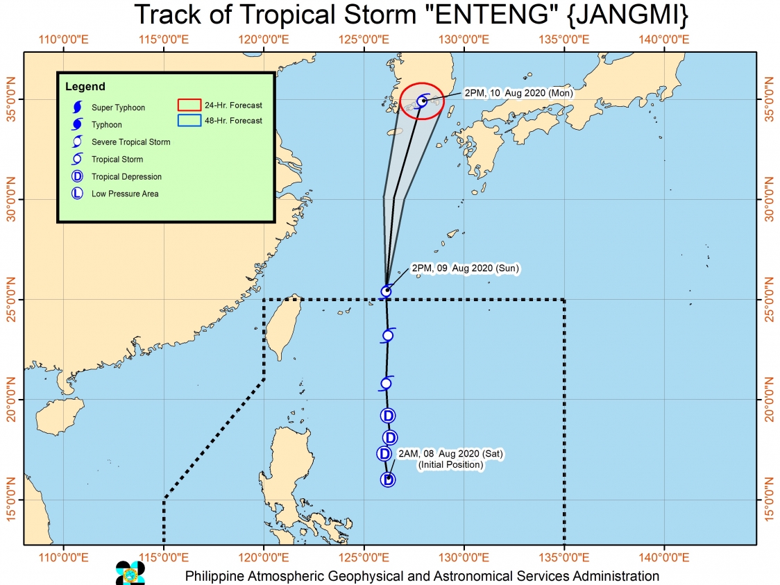
Tropical Storm Enteng (Jangmi) left the Philippine Area of Responsibility (PAR) at 1 pm on Sunday, August 9, without making landfall in any part of the country.
But there is still a low pressure area (LPA) inside PAR and the southwest monsoon or hanging habagat.
The Philippine Atmospheric, Geophysical, and Astronomical Services Administration (PAGASA) said in a bulletin issued 5 pm on Sunday that Enteng is already 730 kilometers northeast of Basco, Batanes.
It is moving north at a still fast 40 kilometers per hour (km/h). According to PAGASA, Enteng will generally head for the East China Sea first, then turn slightly northeast toward South Korea.
The tropical storm maintained its strength as it left PAR, with maximum winds of 75 km/h and gustiness of up to 90 km/h. (READ: FAST FACTS: Tropical cyclones, rainfall advisories)
Meanwhile, the LPA is now 250 kilometers west of Dagupan City, Pangasinan.
PAGASA said the LPA could develop into a tropical depression within the next 24 hours. It is also pulling the southwest monsoon.
The southwest monsoon will continue to affect Luzon and Western Visayas in the next 24 hours. Rainfall is expected to persist in these areas:
Monsoon rain
- Ilocos Region
- Mimaropa
- Abra
- Benguet
- Zambales
- Bataan
- Tarlac
- Pampanga
- Cavite
- Batangas
Occasional rain
- rest of Luzon
- Aklan
- Antique
Areas affected by the southwest monsoon must stay on alert for possible flash floods and landslides.
A gale warning remains in effect in certain seaboards due to rough to very rough seas.
Waves 2.8 to 4.5 meters high
- Pangasinan
- Zambales
- Bataan
- western coast of Batangas
- western coast of Occidental Mindoro including Lubang Island
- western coast of Palawan including Calamian Islands
Waves 2.8 to 4 meters high
- Batanes
- Cagayan including Babuyan Islands
- Isabela
PAGASA also advised those with small vessels to watch out for moderate to rough seas, with waves reaching 1.2 to 2.8 meters high, in the seaboards of the Visayas and the rest of Luzon.
Enteng was the Philippines’ 5th tropical cyclone for 2020.
An average of 20 tropical cyclones form within or enter PAR each year. Only around half of these make landfall. (READ: LIST: PAGASA’s names for tropical cyclones in 2020)
In PAGASA’s climate outlook, it gave the following estimates for the number of tropical cyclones inside PAR for the rest of 2020:
- August – 2 or 3
- September – 2 or 3
- October – 2 or 3
- November – 1 or 2
- December – 1 or 2
PAGASA declared the start of the rainy season on June 12. – Rappler.com
Add a comment
How does this make you feel?
There are no comments yet. Add your comment to start the conversation.