SUMMARY
This is AI generated summarization, which may have errors. For context, always refer to the full article.

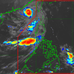
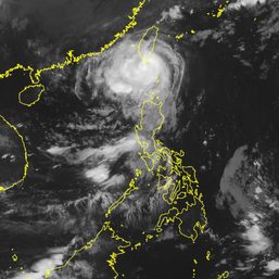
MANILA, Philippines – The raising of Signal No. 1 for the province of Batanes is no longer being ruled out due to the “very expansive wind field” of Typhoon Falcon (Khanun), the Philippines’ weather bureau said early Tuesday, August 1.
Falcon maintained its strength before dawn on Tuesday, with maximum sustained winds of 175 kilometers per hour and gustiness of up to 215 km/h.
Strong to typhoon-force winds extend outwards up to 650 kilometers from the center of the typhoon, according to the Philippine Atmospheric, Geophysical, and Astronomical Services Administration (PAGASA).
Falcon may have already reached its peak intensity and could maintain its strength for the next two days, but PAGASA is still not ruling out intensification into a super typhoon. A super typhoon has maximum sustained winds of 185 km/h or above.
Falcon was last spotted 925 kilometers east northeast of extreme Northern Luzon early Tuesday, moving northwest toward the sea southeast of Japan’s Okinawa Islands at a slightly faster 20 km/h from the previous 15 km/h.
The typhoon is expected to leave the Philippine Area of Responsibility (PAR) on Tuesday afternoon or evening, then pass south of Okinawa Islands between Tuesday evening and Wednesday morning, August 2.
It may see “a period of slow movement” over the East China Sea by Thursday, August 3.
It could also start weakening late Wednesday or early Thursday “as it enters the cooler waters of the East China Sea and as upwelling of deep ocean waters resulting from its slowdown limits further development,” PAGASA said.

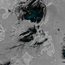
Falcon has not directly brought rain to the Philippines since it has stayed far from land, but it has been enhancing the southwest monsoon or habagat.
On Tuesday, monsoon rain or frequent, heavy rain is again expected in Zambales and Bataan, while occasional rain will persist in Metro Manila, Pangasinan, Pampanga, Bulacan, and Occidental Mindoro.
Scattered rain showers and thunderstorms will also hit the Cordillera Administrative Region, Cagayan Valley, Calabarzon, the rest of the Ilocos Region, the rest of Central Luzon, the rest of Mimaropa, and Antique.
PAGASA warned that floods and landslides remain highly likely.
Gusty conditions due to the enhanced southwest monsoon will also persist in the following areas:
Tuesday, August 1
- Batanes, Babuyan Islands, Abra, Benguet, Zambales, Bataan, central and southern parts of Aurora, Pampanga, Bulacan, Metro Manila, most of Ilocos Region, most of Calabarzon, most of Mimaropa, most of Bicol, most of Western Visayas
Wednesday, August 2
- Batanes, Babuyan Islands, Ilocos Region, most of Cordillera Administrative Region, Nueva Vizcaya, Aurora, Zambales, Bataan, Bulacan, Pampanga, Metro Manila, Calabarzon, Mimaropa, Bicol, western part of Northern Samar, most of Western Visayas
Thursday, August 3
- Batanes, Babuyan Islands, Ilocos Region, Cordillera Administrative Region, Nueva Vizcaya, Aurora, Zambales, Bataan, Bulacan, Pampanga, Metro Manila, Calabarzon, Mimaropa, Bicol, Northern Samar, Western Visayas
The enhanced southwest monsoon is still causing moderate to rough waters in the following seaboards as well:
- western seaboard of Luzon – waves 1.5 to 3 meters high
- southern seaboard of Luzon – waves 1.5 to 2.5 meters high
- northern seaboard of Luzon – waves 1.25 to 2.5 meters high
The weather bureau advised small vessels to take precautionary measures.
Falcon is the Philippines’ sixth tropical cyclone for 2023 and the third for July, coming right after Egay (Doksuri), which pummeled Northern Luzon as a typhoon.
For the next 6 months, PAGASA expects 8 to 11 tropical cyclones to develop within or enter PAR:
- August 2023 – 2 or 3
- September 2023 – 2 or 3
- October 2023 – 2 or 3
- November 2023 – 1 or 2
- December 2023 – 1 or 2
- January 2024 – 0 or 1
– Rappler.com
Add a comment
How does this make you feel?


There are no comments yet. Add your comment to start the conversation.