SUMMARY
This is AI generated summarization, which may have errors. For context, always refer to the full article.

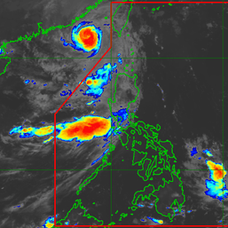
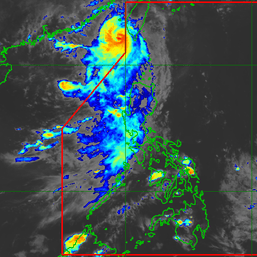
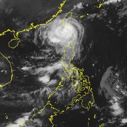
MANILA, Philippines – Typhoon Goring (Saola) was heading for the Luzon Strait in the early hours of Tuesday, August 29, while maintaining its strength and continuing to enhance the southwest monsoon or habagat.
The Luzon Strait is between Luzon and Taiwan, which is also within the Philippine Area of Responsibility (PAR).
Goring was last spotted 220 kilometers east of Aparri, Cagayan, at 4 am on Tuesday. It is still moving north northwest at only 10 kilometers per hour (km/h), completing its looping path over the Philippine Sea.
The typhoon continues to have maximum sustained winds of 155 km/h and gustiness of up to 190 km/h. At its peak, Goring was a super typhoon with maximum sustained winds of 185 km/h.
The Philippine Atmospheric, Geophysical, and Astronomical Services Administration (PAGASA) said in a briefing past 5 am that Goring may follow a mainly northwest or west northwest path across the Luzon Strait from Tuesday until it leaves PAR on Wednesday evening, August 30, or Thursday morning, August 31.
Goring could pass very close to or make landfall in Batanes between Wednesday morning and afternoon. But “a slight southward shift” in its track “may bring the eye and eyewall region of the typhoon to the northern portion of Babuyan Islands,” PAGASA warned.
Also during that time, Goring may re-intensify and possibly “peak at near-super typhoon strength by the time it passes very close [to] or over Batanes.” But the weather bureau is not ruling out a return to super typhoon status for Goring.

Given the latest track and intensity forecast, Signal No. 3 has again been raised. Below are the areas under tropical cyclone wind signals as of 5 am on Tuesday.
Signal No. 3
Storm-force winds (89 to 117 km/h), moderate to significant threat to life and property
- northeastern part of Babuyan Islands (Babuyan Island)
Signal No. 2
Gale-force winds (62 to 88 km/h), minor to moderate threat to life and property
- Batanes
- rest of Babuyan Islands
- extreme northeastern part of mainland Cagayan (Santa Ana, Gonzaga)
Signal No. 1
Strong winds (39 to 61 km/h), minimal to minor threat to life and property
- northern and eastern parts of mainland Cagayan (Camalaniugan, Pamplona, Santa Teresita, Baggao, Buguey, Claveria, Aparri, Ballesteros, Abulug, Sanchez Mira, Santa Praxedes, Allacapan, Lal-lo, Lasam, Peñablanca, Iguig, Amulung, Gattaran, Alcala, Santo Niño)
- eastern part of Isabela (Dinapigue, San Mariano, Ilagan City, Tumauini, San Pablo, Cabagan, Maconacon, Divilacan, Palanan)
- northern part of Apayao (Flora, Calanasan, Luna, Pudtol, Santa Marcela)
- northern part of Ilocos Norte (Vintar, Pasuquin, Burgos, Dumalneg, Adams, Pagudpud, Bangui)
PAGASA warned that Signal No. 4 is the highest possible wind signal for extreme Northern Luzon.
Goring will also trigger more rain on Tuesday and Wednesday, with floods and landslides still expected.
Tuesday, August 29
- 100-200 millimeters (mm): northeastern part of Babuyan Islands
- 50-100 mm: Batanes, rest of Babuyan Islands, northern and eastern parts of mainland Cagayan, Ilocos Norte, northern part of Abra, northern part of Apayao
Wednesday, August 30
- Greater than 200 mm: Batanes, Babuyan Islands
- 100-200 mm: northern part of Ilocos Norte, northwestern part of mainland Cagayan
- 50-100 mm: Apayao, Abra, northern part of Ilocos Sur, northeastern part of mainland Cagayan, rest of Ilocos Norte
ALSO ON RAPPLER
- Pharmally scandal personalities: Where are they now?
- Belmonte to cyclist in road rage video: Come forward, we’ll protect you
- China, Jordan, Iran also slip to 0-2 as Japan remains lone Asian team with FIBA World Cup win
- Luol Deng hailed the ‘heart and soul’ as South Sudan nails first-ever FIBA World Cup win
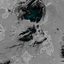
Meanwhile, the enhanced southwest monsoon is dumping rain in the western parts of Central Luzon, Southern Luzon, and the Visayas, especially in Occidental Mindoro.
Areas affected by the enhanced southwest monsoon must watch out for floods and landslides, too.
Monday evening, August 28, to Tuesday evening, August 29
- 100-200 mm: Occidental Mindoro
- 50-100 mm: Zambales, Bataan, Cavite, Batangas, northern part of Palawan including Calamian and Cuyo islands, Antique, southwestern part of Iloilo, northwestern part of Aklan
Tuesday evening, August 29, to Wednesday evening, August 30
- 100-200 mm: Occidental Mindoro
- 50-100 mm: Zambales, Bataan, Cavite, Batangas, northern part of Palawan including Calamian and Cuyo islands, Oriental Mindoro, Antique
Wednesday evening, August 30, to Thursday evening, August 31
- 100-200 mm: Zambales, Bataan, Occidental Mindoro
- 50-100 mm: Metro Manila, Rizal, Bulacan, Cavite, Batangas, Pangasinan
The enhanced southwest monsoon is triggering gusty conditions in these areas as well:
Tuesday, August 29
- Aurora, Bataan, Bulacan, Metro Manila, Calabarzon, Mimaropa, Bicol, Visayas, Dinagat Islands, Camiguin, most of Zamboanga Peninsula
Wednesday, August 30
- Ilocos Region, Zambales, Bataan, Bulacan, Aurora, Metro Manila, Calabarzon, Mimaropa, Bicol, Visayas
Thursday, August 31
- Ilocos Region, Cordillera Administrative Region, Zambales, Bataan, Bulacan, Aurora, Metro Manila, Calabarzon, Mimaropa, Bicol, Western Visayas
Still due to both Goring and the enhanced southwest monsoon, PAGASA released a new gale warning at 5 am on Tuesday. These seaboards are affected:
- northern seaboard of Northern Luzon (Batanes, northern coast of Cagayan including Babuyan Islands) – rough to high seas, with waves 3.1 to 6.5 meters high
- northern and eastern seaboards of Northern Luzon (northern coast of Ilocos Norte, eastern coast of Cagayan, Isabela) – rough to very rough seas, with waves 2.8 to 5 meters high
- western and eastern seaboards of Central Luzon, seaboards of Southern Luzon, seaboards of Visayas, and northern seaboard of Mindanao (Zambales, Bataan, Aurora, Occidental Mindoro, Oriental Mindoro, Palawan, Marinduque, Romblon, Metro Manila, Cavite, Batangas, Quezon including Polillo Islands, Camarines Norte, Camarines Sur, Catanduanes, Albay, Sorsogon, Masbate, Aklan, Antique, Capiz, Iloilo, Guimaras, Negros Occidental, Negros Oriental, Cebu, Bohol, Siquijor, Northern Samar, Eastern Samar, Samar, Biliran, Leyte, Southern Leyte, Camiguin, Dinagat Islands, western coast of Surigao del Norte) – rough to very rough seas, with waves 2.8 to 4.5 meters high
The weather bureau advised fishing boats and other small vessels not to sail, and larger vessels to watch out for big waves.
After Goring’s expected exit from PAR on Wednesday evening or Thursday morning, “increasingly unfavorable conditions over the waters southeast of mainland China will trigger a weakening trend,” according to PAGASA.
“By the time Goring makes landfall in the vicinity of southeastern China…on Sunday (September 3), it will have weakened to minimal typhoon strength,” added the weather bureau.
Goring is the Philippines’ seventh tropical cyclone for 2023 and the first for August. It was also the third super typhoon for the year, after Betty (Mawar) in May and Egay (Doksuri) in July.
PAGASA previously said it expects two or three tropical cyclones to develop within or enter PAR in August.
The second tropical cyclone for August could be the tropical storm with the international name Haikui, which remains outside PAR.
Haikui was last spotted 1,885 kilometers east of Northern Luzon before dawn on Tuesday, still moving west at 20 km/h.
At that rate, it could join Goring inside PAR on Wednesday afternoon or evening. Its local name would be Hanna.
The tropical storm still had maximum sustained winds of 65 km/h and gustiness of up to 80 km/h early Tuesday.
But it is expected to steadily intensify in the next five days, possibly becoming a severe tropical storm on Wednesday – either before or after it enters PAR – and a typhoon on Thursday.

The potential Hanna’s general direction would be west northwest over the Philippine Sea until Friday, September 1 – also the day when it could leave PAR. Then starting Friday evening or Saturday morning, September 2, it could turn northwest as it moves over the East China Sea.
That means the tropical cyclone is seen to stay far from Philippine landmass, and it is “less likely to directly affect the country.”
But it could enhance the southwest monsoon beginning Wednesday or Thursday, which may lead to more monsoon rain in the western parts of Luzon and the Visayas. – Rappler.com
Add a comment
How does this make you feel?




There are no comments yet. Add your comment to start the conversation.