SUMMARY
This is AI generated summarization, which may have errors. For context, always refer to the full article.
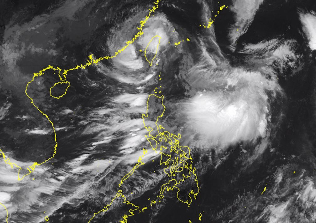
MANILA, Philippines – Typhoon Hanna (Haikui) left the Philippine Area of Responsibility (PAR) at 8 am on Monday, September 4, but it will continue to enhance the southwest monsoon or habagat.
As of 10 am, Hanna was already 360 kilometers northwest of Itbayat, Batanes, moving north northwest at a faster 15 kilometers per hour (km/h) from its previous slow pace.
The typhoon maintained its strength, with maximum sustained winds of 120 km/h and gustiness of up to 165 km/h.
The Philippine Atmospheric, Geophysical, and Astronomical Services Administration (PAGASA) lifted Signal No. 1 for Batanes following Hanna’s exit.
The typhoon did not make landfall in the Philippines, but it hit Taiwan, which is above Batanes and within PAR.
PAGASA expects Hanna to gradually weaken as it moves over the Taiwan Strait. It could make landfall in Guangdong or Fujian in China on Tuesday morning or afternoon, September 5, as a severe tropical storm.
“Rapid weakening will ensue as the tropical cyclone moves further inland over Guangdong, China,” added the weather bureau.
By late Wednesday, September 6, or Thursday, September 7, Hanna may just be a remnant low.

PAGASA warned that a few provinces will still have heavy to intense rain from the enhanced southwest monsoon on Monday, while other areas are seeing moderate to heavy rain.
Rain could gradually begin easing on Tuesday, when Hanna is likely to be a weaker tropical cyclone as it hits China.
But PAGASA advised affected areas to remain on alert for floods and landslides in the next three days.
Monday, September 4
- 100-200 millimeters (mm): Pangasinan, Zambales, Bataan
- 50-100 mm: Metro Manila, Ilocos Norte, Ilocos Sur, La Union, Abra, Benguet, Tarlac, Nueva Ecija, Pampanga, Bulacan, Rizal, Cavite, Batangas, Occidental Mindoro, Calamian Islands
Tuesday, September 5
- 50-100 mm: Metro Manila, Ilocos Region, Abra, Benguet, Zambales, Bataan, Tarlac, Nueva Ecija, Pampanga, Bulacan
Wednesday, September 6
- 50-100 mm: Ilocos Region, Zambales

Gusty conditions due to the enhanced southwest monsoon also persist in these areas:
Monday, September 4
- Batanes, Babuyan Islands, Ilocos Region, Cordillera Administrative Region, Nueva Vizcaya, southern part of Aurora, Zambales, Bataan, Bulacan, Metro Manila, Occidental Mindoro, Romblon, Marinduque, northern part of Palawan including Calamian, Kalayaan, and Cuyo islands, most of Calabarzon, most of Bicol, most of Western Visayas
Tuesday, September 5
- Batanes, Babuyan Islands, Ilocos Region, Abra, Benguet, Nueva Vizcaya, southern part of Aurora, Zambales, Bataan, Bulacan, Metro Manila, Occidental Mindoro, Romblon, Marinduque, Kalayaan Islands, Camarines Norte, Camarines Sur, most of Calabarzon
Wednesday, September 6
- Batanes, Ilocos Norte, western part of Pangasinan, Kalayaan Islands
ALSO ON RAPPLER
- Rappler Talk: Miriam Coronel-Ferrer on putting more women at the peace table
- ‘Punched us in the mouth’: Olympic berth hardly eases first USA loss
- X privacy policy update confirms use of public data to train AI models
- Joe Jonas, Sophie Turner to divorce – reports
Meanwhile, the gale warning issued at 5 am on Monday remains in effect. The following seaboards have rough to very rough waters due to Hanna and the enhanced southwest monsoon:
- seaboards of extreme Northern Luzon (Batanes) – waves 2.8 to 5 meters high
- western seaboard of Central Luzon and Southern Luzon (Zambales, Bataan, Occidental Mindoro including Lubang Island, northern part of Palawan including Calamian, Cuyo, and Kalayaan Islands) – waves 2.8 to 4.5 meters high
- western seaboard of Northern Luzon (Ilocos Norte, Ilocos Sur, La Union, Pangasinan) – waves 2.8 to 4.5 meters high
- southern seaboard of Southern Luzon and western seaboard of Visayas (Oriental Mindoro, Marinduque, Romblon, Antique, Aklan) – waves 2.8 to 4.5 meters high
- eastern seaboard of Northern Luzon (Cagayan including Babuyan Islands, Isabela) – waves 2.8 to 4.5 meters high
The weather bureau advised fishing boats and other small vessels not to sail, and larger vessels to watch out for big waves.
Hanna, which entered PAR last Wednesday, August 30, was the Philippines’ eighth tropical cyclone for 2023.
For the next 6 months, PAGASA estimated that 6 to 9 tropical cyclones may form within or enter PAR:
- September 2023 – 2 or 3
- October 2023 – 2 or 3
- November 2023 – 1 or 2
- December 2023 – 1 or 2
- January 2024 – 0 or 1
- February 2024 – 0 or 1
– Rappler.com
Add a comment
How does this make you feel?


There are no comments yet. Add your comment to start the conversation.