SUMMARY
This is AI generated summarization, which may have errors. For context, always refer to the full article.
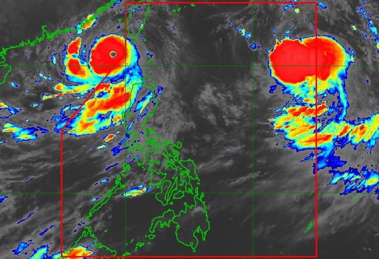
MANILA, Philippines – Super Typhoon Goring (Saola) exited the Philippine Area of Responsibility (PAR) at 7:50 pm on Wednesday, August 30, while Severe Tropical Storm Hanna (Haikui) entered over an hour later at 9 pm.
The Philippine Atmospheric, Geophysical, and Astronomical Services Administration (PAGASA) said Goring was already 265 kilometers west of Itbayat, Batanes, as of 10 pm on Wednesday.
The super typhoon continues to move west northwest outside PAR, but it slightly slowed down to 10 kilometers per hour from 15 km/h. It will be heading for the waters off Guangdong, China.
Goring also maintained its strength, with maximum sustained winds of 195 km/h and gustiness of up to 240 km/h. This has been its peak intensity, so far.
PAGASA expects Goring to eventually weaken into a typhoon on Thursday, August 31; a severe tropical storm on Saturday, September 2; and a tropical storm on Sunday, September 3.
Goring had developed from a low pressure area off Cagayan on August 24. It did not make landfall in the Philippines, but triggered torrential rain and fierce winds in parts of Northern Luzon.
With its exit, there are no more areas under tropical cyclone wind signals. Signal No. 5 was the highest wind signal raised.
But Goring’s outer rainbands may still bring moderate to heavy rain to Ilocos Norte, Ilocos Sur, the western part of Pangasinan, Abra, and the western part of Apayao until Thursday. Floods and landslides remain possible.

Meanwhile, Hanna was located 1,335 kilometers east of extreme Northern Luzon as of 10 pm on Wednesday, moving northwest at 15 km/h.
The severe tropical storm slightly weakened again, with its maximum sustained winds down to 95 km/h from 100 km/h. Its gustiness eased further to 115 km/h from 125 km/h.
But PAGASA said Hanna may slowly intensify inside PAR and become a typhoon on Friday, September 1.
The good thing is that Hanna is projected to remain far from Philippine landmass, which means it is unlikely to directly bring rain to any part of the country.
There are also no tropical cyclone wind signals raised due to the severe tropical storm, and it is “less likely” to cause rough sea conditions, according to PAGASA.
Hanna could exit PAR on Friday afternoon or evening, then make landfall in mainland China on Sunday. “Rapid weakening will ensue following its landfall over mainland China,” the weather bureau said.

Aside from Goring and Hanna, PAGASA continues to monitor the impact of the enhanced southwest monsoon or habagat.
Goring will still enhance the southwest monsoon even if it is already outside PAR. At the same time, the southwest monsoon is also being slightly enhanced by Hanna.
The weather bureau warned that the western part of Luzon will have rain from the enhanced southwest monsoon in the next three days.
Wednesday night, August 30, to Thursday night, August 31
- 100-200 mm: Zambales, Bataan, Occidental Mindoro
- 50-100 mm: Metro Manila, La Union, Pangasinan, Benguet, Tarlac, Pampanga, Bulacan, Calamian Islands
Thursday night, August 31, to Friday night, September 1
- 100-200 mm: Zambales, Bataan, Occidental Mindoro
- 50-100 mm: Metro Manila, Ilocos Region, Abra, Benguet, Tarlac, Nueva Ecija, Pampanga, Bulacan, Rizal, Calamian Islands
Friday night, September 1, to Saturday night, September 2
- 100-200 mm: Zambales, Bataan, Occidental Mindoro
- 50-100 mm: Metro Manila, Ilocos Region, Tarlac, Nueva Ecija, Pampanga, Bulacan, Rizal, Cavite, Batangas, Calamian Islands
Affected regions and provinces should stay on alert for floods and landslides.
ALSO ON RAPPLER
- How Metro Manila’s train system fails persons with disabilities
- Families of the disappeared seek justice through implementation of landmark law
- ‘Hindi namin kayo tatantanan,’ ‘Excuse me po,’ and other Mike Enriquez quotes
- [In This Economy] Spare a thought for the PH’s 90% learning poverty rate
- Clarkson, Fontecchio trade praises after World Cup match
Gusty conditions due to the enhanced southwest monsoon will also persist in these areas:
Thursday, August 31, and Friday, September 1
- Ilocos Region, Cordillera Administrative Region, Zambales, Bataan, Aurora, Bulacan, Metro Manila, Calabarzon, Mimaropa, Bicol, Western Visayas, northern part of Eastern Visayas
Saturday, September 2
- Zambales, Bataan, Aurora, Bulacan, Metro Manila, Calabarzon, Mimaropa, Bicol, Western Visayas, northern part of Eastern Visayas
Most seaboards of Luzon and the Visayas, as well as the eastern seaboard of Mindanao, remain under a gale warning, too.

Goring and Hanna are the Philippines’ seventh and eighth tropical cyclones for 2023, respectively. Goring was also the third super typhoon for the year, after Betty (Mawar) in May and Egay (Doksuri) in July.
PAGASA previously estimated there would be two or three tropical cyclones in August. – Rappler.com
Add a comment
How does this make you feel?


There are no comments yet. Add your comment to start the conversation.