SUMMARY
This is AI generated summarization, which may have errors. For context, always refer to the full article.
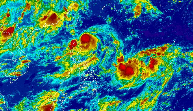
MANILA, Philippines – After “a period of rapid intensification,” Goring (Saola) reached typhoon status on Friday evening, August 25.
Its maximum sustained winds increased to 120 kilometers per hour from the previous 110 km/h when it was a severe tropical storm, said the Philippine Atmospheric, Geophysical, and Astronomical Services Administration (PAGASA) in a briefing past 11 pm on Friday.
The typhoon’s gustiness is now up to 150 km/h from 135 km/h.
In the early hours of Friday, Goring’s maximum sustained winds were only at 75 km/h.
Goring is also projected to keep intensifying, and may become a super typhoon on Monday, August 28 – a regular holiday in the country for National Heroes Day.
It was last spotted 205 kilometers east of Calayan, Cagayan, moving south southwest at only 10 km/h on Friday evening.
ALSO ON RAPPLER
- Clarkson fouls out as Gilas Pilipinas falls short vs Dominican Republic in FIBA World Cup opener
- FIBA attendance record shattered as Gilas Pilipinas opens World Cup bid vs Dominican Republic
- POV: School bags from Taguig, Makati LGUs
As of 11 pm on Friday, Signal No. 2 has been raised due to Goring for the first time. Below are the areas under tropical cyclone wind signals.
Signal No. 2
Gale-force winds (62 to 88 km/h), minor to moderate threat to life and property
- extreme northeastern part of mainland Cagayan (Santa Ana)
Signal No. 1
Strong winds (39 to 61 km/h), minimal to minor threat to life and property
- Batanes
- Babuyan Islands
- eastern part of mainland Cagayan (Gonzaga, Lal-lo, Gattaran, Baggao, Peñablanca, Santa Teresita, Buguey, Camalaniugan, Aparri)
- eastern part of Isabela (Maconacon, Dinapigue, San Mariano, San Pablo, Cabagan, Tumauini, Ilagan City, Divilacan, Palanan)
- northern part of Aurora (Dilasag, Casiguran)
Floods and landslides are also possible as the typhoon is bringing moderate to torrential rain. Here is PAGASA’s updated rainfall forecast:
Friday night, August 25, to Saturday night, August 26
- 100-200 millimeters (mm): extreme northeastern part of mainland Cagayan
- 50-100 mm: Babuyan Islands, northwestern and eastern parts of mainland Cagayan, northeastern part of Isabela, Abra, Apayao, Ilocos Norte, Ilocos Sur
Saturday night, August 26, to Sunday night, August 27
- 100-200 mm: extreme northeastern part of mainland Cagayan
- 50-100 mm: Babuyan Islands, northwestern and eastern parts of mainland Cagayan, eastern part of Isabela, Ilocos Norte, northern part of Aurora
The gale warning due to Goring issued at 5 pm on Friday remains in effect as well. Rough to very rough seas, with waves 2.8 to 4.5 meters high, are expected in these seaboards:
- northern and eastern seaboards of Northern Luzon (Batanes, Cagayan including Babuyan Islands, Isabela)
- eastern seaboard of Central Luzon (Aurora)
PAGASA advised fishing boats and other small vessels not to sail, and larger vessels to watch out for big waves.
During the weekend, Goring is expected to move south to southeast off the Cagayan Valley region. Then it may turn northeast to north on Monday, before speeding up toward the sea east of Taiwan on Tuesday, August 29, and Wednesday, August 30.
Taiwan is within the Philippine Area of Responsibility (PAR).

Goring is also enhancing the southwest monsoon or habagat, which will affect the following areas and may also trigger floods and landslides:
Friday night, August 25, to Saturday night, August 26
- 50-100 mm: Zambales, Bataan, Occidental Mindoro
Saturday night, August 26, to Sunday night, August 27
- 100-200 mm: Occidental Mindoro
- 50-100 mm: Zambales, Bataan, Cavite, Batangas, northern part of Palawan including Calamian and Cuyo islands, Antique
Sunday night, August 27, to Monday night, August 28
- 100-200 mm: Occidental Mindoro
- 50-100 mm: Zambales, Bataan, Cavite, Batangas, northern part of Palawan including Calamian and Cuyo islands, Western Visayas
The enhanced southwest monsoon will also trigger gusty conditions in these areas:
Saturday, August 26
- Aurora, Bataan, Metro Manila, Calabarzon, Bicol, most of Mimaropa
Sunday, August 27
- Aurora, Bataan, Metro Manila, Calabarzon, Mimaropa, Bicol, Visayas, Dinagat Islands, Camiguin
Monday, August 28
- Aurora, Bataan, Metro Manila, Calabarzon, Mimaropa, Bicol, Visayas, Dinagat Islands, Camiguin, most of Zamboanga Peninsula
Goring is the Philippines’ seventh tropical cyclone for 2023 and the first for August.
PAGASA previously said it expects two or three tropical cyclones to develop within or enter PAR in August.
The weather bureau also continues to monitor a low pressure area (LPA) that formed outside PAR on Friday. It was located 1,870 kilometers east of the Visayas on Friday evening.
PAGASA Weather Specialist Benison Estareja said the LPA will remain far from the country and will have no direct effect in the coming days. – Rappler.com
Add a comment
How does this make you feel?


There are no comments yet. Add your comment to start the conversation.